In Db2® Spatial Extender, a geographic
feature can be represented by one or more data items; for example, the data items in a row of a
table.
A data item is the value or values that occupy a cell of a
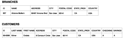
relational table. For example, consider office buildings and residences. In Figure 1, each row of the BRANCHES table represents a branch office of a
bank. Similarly, each row of the CUSTOMERS table in Figure 1, taken
as a whole, represents a customer of the bank. However, a subset of each row-specifically, the data
items that constitute a customer's address-represent the customer's residence.Figure 1. Data that represents geographic features. The row of data in the BRANCHES table represents a branch office of a bank. The address data
in the CUSTOMERS table represents the residence of a customer. The names and addresses in both
tables are fictional.
The tables in Figure 1 contain
data that identifies and describes the bank's branches and customers.
This discussion refers to such data as business
data.
A subset of the business data-the values that denote the branches'
and customers' addresses-can be translated into values from which
spatial information is generated. For example, as shown in Figure 1, one branch office's address
is 92467 Airzone Blvd., San Jose, CA 95141, USA. A customer's address
is 9 Concourt Circle, San Jose, CA 95141, USA. Db2 Spatial Extender can translate these addresses
into values that indicate where the branch and the customer's home
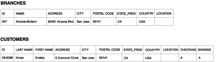
are located with respect to one another. Figure 2 shows the BRANCHES
and CUSTOMERS tables with new columns that are designated to contain
such values.Figure 2. Tables with spatial columns
added. In each table, the LOCATION column will contain
coordinates that correspond to the addresses.
Because spatial information will be derived from the data items
stored in the LOCATION column, these data items are referred to in
this discussion as spatial data.